 |
| |
Twin Peaks, California U.S.A 92391
San Bernardino County Mountains 5,715ft
 A Worldwide Weather Network
Site.
A Worldwide Weather Network
Site. 
APRS / NOAA / CWOP STATION ID'S AR725 - WA6TJQ
WEATHER UNDERGROUND STATION - KCATWINP29
Current Weather Conditions
![]() Refresh
This Page For The Latest Weather Report.
Refresh
This Page For The Latest Weather Report.
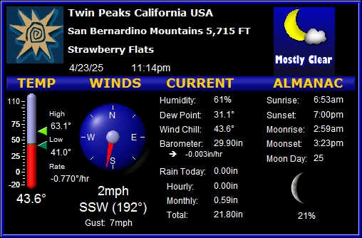
(HIGH /LOW WEATHER READINGS FOR TODAY)
(WUNDERGROUND)
![]()
![]() CLICK
HERE FOR
MY WEATHER UNDERGROUND DATA
CLICK
HERE FOR
MY WEATHER UNDERGROUND DATA
(HAM RADIO
APRS WEATHER INFORMATION)
![]()
APRS
TWIN PEAKS WEATHER STATION DISPLAY
![]()
APRS
TWIN PEAKS WEATHER STATION GRAPHS ![]()
(OTHER IMPORTANT WEATHER LINKS)
|
|